













Interested in the environment, experts at LeLynx.fr sought to find out which French urban areas have the most green space.
To do so, LeLynx.fr created an index taking into consideration areas of forest, artificial green urban areas, and herbaceous vegetation associations, to calculate the total green area percentage within each French urban area.
The full data set, which analyses 85 French cities, can be found here.
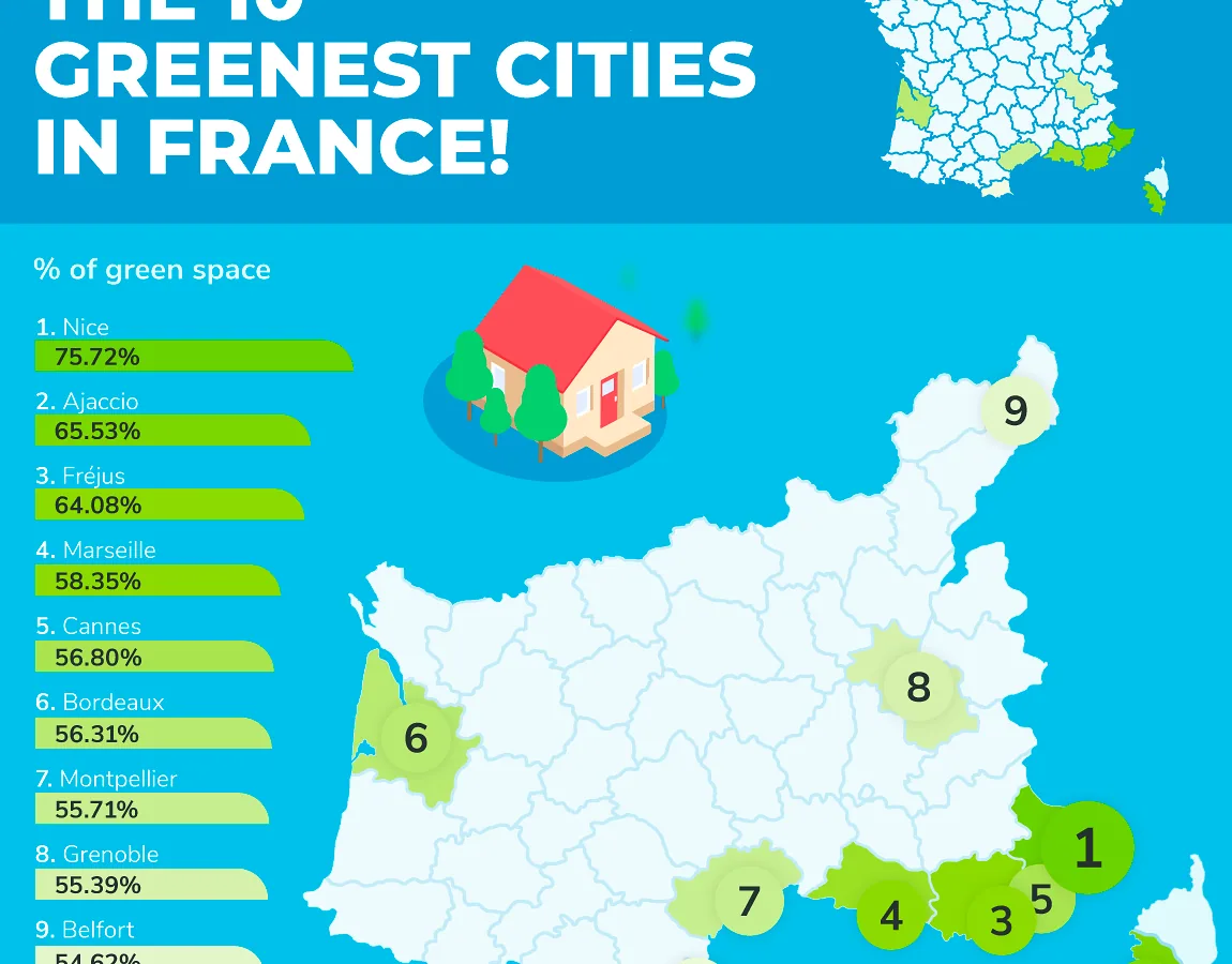
These are the top 10 greenest urban areas in France!
With a whopping 75.72% of green areas, Nice is crowned the greenest French urban area! Those who live or travel to Nice get to experience not only plenty of vegetation but can enjoy strolls on the beach and bike rides on some of the best roads in Europe.
The second greenest French urban area is the port city Ajaccio, also the capital of Corsica. With 65.53% of its total area covered in trees and greenery, Ajaccio is the perfect destination for those who enjoy sunbathing on the beach or those who prefer being active and exploring on foot or by bike.
In third place, we have Fréjus, with 64.08% green areas. A port town on the Côte d’Azur, Fréjus is not only worth exploring for its nature, but for its rich architecture and monuments such as Amphithéâtre de Fréjus and Aqueduc de Mons à Fréjus.
Marseille is the fourth greenest urban area in France with 58.35% green areas. The city was founded in 600 BC by Greek settlers from Phocaea and is the oldest French city. One of the most picturesque cities, there are plenty of striking views and eye-catching landscapes to explore.
Other notable green urban areas in the study making it in the top 10 are: Cannes (56,80%) Bordeaux (56.31%), Montpellier (55.71%), Grenoble (55.39%), Belfort (54.62%) and Perpignan (52,42%).
These are the LEAST green urban areas in France!
At the other end of the scale, the least green urban area in France is Dunkerque, a coastal city in northern France, with only 3.37% of its area covered in trees and vegetation. However, if you are a history fan, and would like to walk the same famous beach soldiers walked during the Dunkirk evacuation in World War II, this is a spectacular place to visit.
Arras is the second least green urban area in France, with only 4.05% vegetation and trees covering its land. The city is located in northern France, and it attracts thousands of visitors every year.
The third least green urban area in France is La Rochelle (5.12% greenery and trees), a coastal city in southwestern France and the capital of the Charente-Maritime department. The city has been the centre for fishing and trade since the 12th century.
With 5.77% green areas, Lille is the fourth least green French city. Located in northern France, Lille is known as a cultural hub.
Lille is followed by Saint-Quentin, the fifth least green urban area in France, with only 5.86% green spaces. The commune is also located in northern France, and it has been identified as the Augusta Veromanduorum of antiquity.
–
Methodology
- fr undertook this research to identify the cities/towns in France with the largest relative green space coverage. This research draws insights from the Pan-European Copernicus Land Monitoring Service which provides spatial land cover data throughout Europe. For each of the 85 towns/cities analysed, the evaluation metric was based on the relative spatial density of green space within its Functional Urban Area (FUA).
- Firstly, the Urban Atlas 2018 dataset was used to collect the total surface area (KM2) within each FUA consisting of green space classes including Forests, Green Urban Areas, and Herbaceous Vegetation (soft-stemmed plants). These were collected along with the total surface area of the FUA.
- It is important to note that, the Functional Urban Area is composed of a city and its commuting zone which encompass the economic and functional extent of cities based on daily people’s movements (OECD, 2019). These boundaries were preferable to narrower city/town boundaries as they reflect more accurately the spatial landscape experienced by inhabitants and travellers alike.
- To create a ranking metric, the percentage of total green space surface area (KM2) to total FUA surface area (KM2) was calculated and ranked by. The final table describes the total surface area of each green space class and its relative percentage of the FUA along with the total green space area and percentage.

All Inclusive
Luksusowy kwartalnik turystyczno-podróżniczy. Od 2004 roku opisujemy miejsca, do których warto lecieć dłużej niż na weekend, i ludzi, którzy je prowadzą.